| Sign In | Join Free | My carsrow.com |
|
| Sign In | Join Free | My carsrow.com |
|
| Categories | Aerial Mapping Drone |
|---|---|
| Brand Name: | Accept Customization |
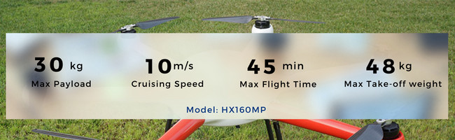
| Model Number: | HX160MP |
| Certification: | CE, FCC, RoHS, REACH, KC, SAA, PSE, Brand Authorization, etc. |
| Place of Origin: | China |
| MOQ: | 1 |
| Payment Terms: | L/C, D/A, D/P, T/T, Western Union, MoneyGram |
| Supply Ability: | 200 Sets/ Month |
| Delivery Time: | 7days |
| Packaging Details: | Packaging Specific To Aerial Mapping Drone |
| Drone Keywords: | Aerial Mapping Drone |
| OEM&ODM: | Available |
| Wheelbase: | 5.8kg |
| Take-off Weight: | 48kg |
| Flight Time: | ≥45min(4x6s 16000mah) |
| Max Effective Load: | 30kg |
| Max Descent Speed: | 4m/s |
| Max Lifting Speed: | 5m/s |
| Company Info. |
| HX DRONE Technology Co., LTD |
| View Contact Details |
| Product List |
HX160MP Six-Axis 6-Rotor UAV Load 30KG 3D 4D Urban Modeling Surveying Street Aerial Mapping Drone
Features and Advantages
HX160MP is a new integrated flight platform. The lightweight design and heavy-duty power system greatly improve the performance and reliability of the multi-rotor industrial drone.
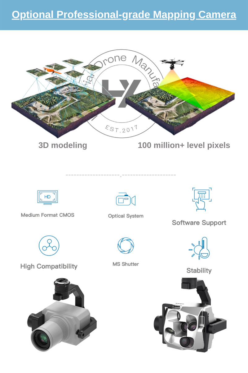
The large space design between the center plate and the ground allows the drone to mount a variety of equipment, suitable for various industries: aerial photography, emergency rescue, reconnaissance missions, remote sensing surveys, surveying and mapping, etc.
Equipped with N3 flight control system
The N3 industrial multi-rotor flight control system adopts DJI's latest control and navigation algorithm, and the newly added built-in dual IMU redundancy design can realize real-time data backup for each other. Combined with the new internal shock absorption structure design, it gives the aircraft high reliability.
Compatible with DJI Accessories
At the same time, HX160MP supports a series of DJ | accessories including Lightbridge 2, DJI Assistant 2, etc. The rich application expansion can help drone enthusiasts and industry application explorers to provide stable and comprehensive system-level solutions.
| HX160MP Specifications Aerial Mapping Drone | ||||
|---|---|---|---|---|
| Wheelbase | 1620mm | |||
| Frame Weight | 5.8kg(with landing gear) | |||
| Take-off Weight | ≥48kg | |||
| Flight Time | ≥45min(4x6s 16000mah) | |||
| Max Effective Load | 30kg | |||
| Max flying Speed | 10m/s | |||
| Max Lifting Speed | 5m/s | |||
| Max Descent Speed | 4m/s | |||
| Max Angle of Inclination | 45° | |||
| Suggested Flight Altitude | ≤500m | |||
| Working Temperature | -10 ~ +55 ℃ | |||
| Hover Precision | Vertical Direction ±0.5m, Horizontal Direction:±1.5 m | |||
Why Choose Us?
*We support Customizing Aerial Mapping Drone according to your work scene needs.
*HX Drone Factory started the drone business in 2017, reliable
R&D capability and manufacturing capability are our core
competitiveness.
*The goods can be sent to all over the world by international
express within 7 days at the fastest.
*We have a 7*24 Hours After-Sales Service Team, which can solve
various problems you encounter through online chat and video
conference.

|
